-
About
District Introduction
History & Tradition
Geographical & Economic
Others
- Political Personalities
-
Newspapers
-
Hotels and Accommodation
-
National Youth Awards and Commonwealth Youth Award Recipients
-
District level officials list and mobile number
-
Sheikh Russel Digital Lab in Natore
-
Sheikh Russel Digital Lab Report Format
-
All UDC & PDC List
-
SRDL ICT Teachers
-
List of Food Beneficiaries
-
Administration
Deputy Comissioner
Office of the Deputy Commissioner
DDLG/Additional Deputy Commissioner
Officers and Staffs
About Sections
Important Information
-
Govt. Offices
Law Discipline & Security Issues
Education & Culture
Agriculture & Food
-
District Food Office
-
Agriculture Extension Office
-
District Fisheries Office
-
District Livestock Office
-
BADC
-
District BADC (Irrigation)
-
Jute Inspection Office
-
District Agricultural Information Office
-
Barind Multipurpose Development Authurity
-
Bangladesh Food Safety Authority, Natore
-
Small Farmer Development Foundation, Regional Office, Natore
-
District Artificial Insemination Center, Natore
-
Office of Agriculture Marketing Officer, Natore
Engineering & ICT
-
District Information & Communication Technology Ofifce
-
Department of Health Engineering
-
Department of Roads and Highways
-
Bangladesh Power Development Board
-
Public Works Department
-
Department of Public Health Engineering.
-
Water Development Board
-
Education Engineering Department
-
Local Government Engineering Department
-
Rural Electrification Board, Natore
Health
Communication & Engineering
Human Resources Development
-
Islamic Foundation
-
Department of Youth Development, Natore
-
Barendra Multipurpose Development Authority
-
District Women Affairs Officer\'s Office, Natore.
-
District Social Welfare Office, Natore
-
Bangladesh Rural Development Board, Natore District Office.
-
District Co-operative Office, Natore
-
District Hindu Religious Welfare TrustOffice
-
Protibondhi Sheba O Sahajjo Kendro, Natore
-
Amar Bari Amar Khamar Project
-
প্রবেশন অফিসারের কার্যালয়, নাটোর
-
Sorkari Shishu Poribar(Boys),Natore
Other Offices
More
-
District Savings Office
-
North Bengal Sugar Mills Ltd. Gopalpur, Lalpur, Natore
-
Natore Sugar Mill
-
Natore Palli Bidyut Samity-1
-
Natore Palli Bidyut Samity-2
-
Assistant Forest Conservator\'s Office, Social Forest Division, Natore
-
District Election Officer\'s Office, Natore
-
BSCIC District Office, Natore
-
PDBF Natore
-
Government Child Family (Boys) Natore
-
Tax Office Natore
-
Department of Environment, Natore District Office, Natore
-
District Food Office
- Local Government
-
Other Organizations
Organizations
Educational Institutions
-
e-Services
e-Services
National E-Service
Mobile App
- Gallery
- Uttara Ganabhaban
- Online Dealing License
- Forms
- Tourism Service
-
About
District Introduction
History & Tradition
Geographical & Economic
Others
- Political Personalities
- Newspapers
- Hotels and Accommodation
- National Youth Awards and Commonwealth Youth Award Recipients
- District level officials list and mobile number
- Sheikh Russel Digital Lab in Natore
- Sheikh Russel Digital Lab Report Format
- All UDC & PDC List
- SRDL ICT Teachers
- List of Food Beneficiaries
-
Administration
Deputy Comissioner
Office of the Deputy Commissioner
DDLG/Additional Deputy Commissioner
Officers and Staffs
About Sections
Important Information
-
Govt. Offices
Law Discipline & Security Issues
Education & Culture
Agriculture & Food
- District Food Office
- Agriculture Extension Office
- District Fisheries Office
- District Livestock Office
- BADC
- District BADC (Irrigation)
- Jute Inspection Office
- District Agricultural Information Office
- Barind Multipurpose Development Authurity
- Bangladesh Food Safety Authority, Natore
- Small Farmer Development Foundation, Regional Office, Natore
- District Artificial Insemination Center, Natore
- Office of Agriculture Marketing Officer, Natore
Engineering & ICT
- District Information & Communication Technology Ofifce
- Department of Health Engineering
- Department of Roads and Highways
- Bangladesh Power Development Board
- Public Works Department
- Department of Public Health Engineering.
- Water Development Board
- Education Engineering Department
- Local Government Engineering Department
- Rural Electrification Board, Natore
Health
Communication & Engineering
Human Resources Development
- Islamic Foundation
- Department of Youth Development, Natore
- Barendra Multipurpose Development Authority
- District Women Affairs Officer\'s Office, Natore.
- District Social Welfare Office, Natore
- Bangladesh Rural Development Board, Natore District Office.
- District Co-operative Office, Natore
- District Hindu Religious Welfare TrustOffice
- Protibondhi Sheba O Sahajjo Kendro, Natore
- Amar Bari Amar Khamar Project
- প্রবেশন অফিসারের কার্যালয়, নাটোর
- Sorkari Shishu Poribar(Boys),Natore
Other Offices
More
- District Savings Office
- North Bengal Sugar Mills Ltd. Gopalpur, Lalpur, Natore
- Natore Sugar Mill
- Natore Palli Bidyut Samity-1
- Natore Palli Bidyut Samity-2
- Assistant Forest Conservator\'s Office, Social Forest Division, Natore
- District Election Officer\'s Office, Natore
- BSCIC District Office, Natore
- PDBF Natore
- Government Child Family (Boys) Natore
- Tax Office Natore
- Department of Environment, Natore District Office, Natore
- Local Government
-
Other Organizations
Organizations
Educational Institutions
-
e-Services
e-Services
National E-Service
Mobile App
-
Gallery
Photo Gallery
Video Gallery
-
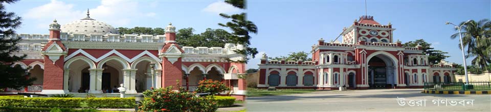
Uttara Ganabhaban
উত্তরা গণভবন পরিচিতি
-
Online Dealing License
অনলাইন ডিলিং লাইসেন্স আবেদন
-
Forms
Forms
-
Tourism Service
Tourism Cell
Area 1896.05 square kilometers
Population: (as of 2011 census) 1706673; Male 854183, Female 852490, Muslim 1590919 (93.22%), Hindu 103747 (6.08%), Christian 8058 (0.47%), Buddhists 7 (0.00%), Other 3946 John (0.23%), Annual population growth rate of 1.40%, estimated population of 2016 according to annual population growth of 182,140
Election area 04; (58) Natore-1 (Lalpur-Bagatipara), (59) Natore-2 (Natore Sadar-Naldanga), (60) Natore-3 (Singra), (61) Natore -4 (Gurdaspur-Baraigram)
Total number of voters is 105023; Male 514186, female 536087 people
Upazila 07; Natore Sadar, Singra, Gurudaspur, Baraigram, Lalpur, Bagatipara, Naldanga
Thana 07; Natore Sadar, Singra, Gurudaspur, Baraigram, Lalpur, Bagatipara, Naldanga
Municipality 08; Natore (K-class), Singra (K-class), Gurudaspur (K-class), Baraigar (B-class), Banpara (c-class), Gopalpur (c-class), Bagatipara (c-class), Naldanga (C-class)
Union 52; Natore Sadar-7, Singra-12, Gurdaspur -6, Baraigram-7, Lalpur-10, Bagatipara-5, Naldanga-5
Village 1434
City Corporation No
School Primary School (Government and Private) -658, Lower Secondary - 63, Secondary - 288, Dakhil Madrasa - 121, Community School - 37
College Public and Private - 106, Madrasa (Alim, Fazil, Kamil) - 26
Mouza 1265
River Nandaku, Baranai, Godai, Baral, Gunayi, Narad River
The closed waterfront 669 (20 acres and up to 20 acres)
Open Jalmahal 14
Hats bazaar 170
Total land Crop land 301856 hectares
Total cultivable land 150838 hectares, one crop 34675 hectares, two crops 81515 hectares, three crop 34441 hectares
52 of the Union Land Offices
Pucca Road is 656.00 kilometers
The mud road is 2251.50 kilometers
Housing / Shelter Scheme 09
Ideal Village 28
Khayagat / Boataghat 11
Tourist places of Dighapatiya Rajbari (Uttara Ganobhaban), Natore Rajbari, Chaugam Zamindar Bari
Indigenous population 20530
Population density -
Parliamentary constituency 04
Geographical location and area are Bogra and Naogaon districts, Sirajganj and Pabna districts on the east, Pabna and Kushtia districts on the south, Rajshahi district on the west. Area 1896.05 square kilometers
Number of educational institutions in total 1243; Middle Secondary, 63, Secondary, 285, Dakhil Madrasa 121, Primary School (Government and Private) 658, Community Schools 37, College (Public and Private) 106, Madrasa (Alim, Fazil, Kamil)
Literacy rate among the town people is 65%
Health district hospital 01, upazila health complex 05, union family welfare center 30, union sub-center 15, community clinic 159, private clinic 43
Agriculture Total land area 301856 hectares, total arable land 150838 hectares, one crop 34675 hectares, two crops 81515 hectares, three crops 34441 hectares, agricultural land 2998499, crop intensity 200.12%, total crop land under irrigation 122430 hectares (55%) , Chara forest 2340 hectares
Natural Resources -
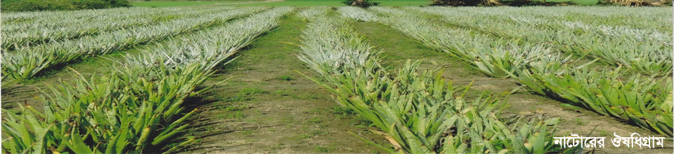
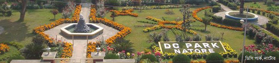
Tourism in the possibility field. If the tourism zone is built with Rani Bhabani's Rajbari, Uttara Ganobhaban, Chalanabil, Halti Bills and other spectacular historic establishments, it can play a significant role in socio-economic development of the region.
Khas Land Total Khas Land 30637 Acres, Agriculture 13468.2 Acres, Non-Agriculture 17168.8 Acres
Noted educational institutions Nawab Siraj Uddh-Daula Government College, Rani Bhabani Government Women's College, Dighapatiya MK Degree College, Collective Public School and College, Government Boys High School, Government Girls High School, Maharaja JN High School
Number of primary school visits -
Mosques, temples, churches, religious places
Cluster 01 (under implementation); Pirzipara, Natore Sadar
District prison 01
NGOs 64
The main problem of the district -
Communication systems Roads and railways
Banks -
Press Club 01; District Press Club, Natore
Cultural organizations, District Shilpakala Academy, Monobina Sangha, Sakam Cultural Institute, Natore Music School, Usha Khelaghar Asar, Bholamon Baul Association, Ichalabari Baul Association, Nothinggan, Ding Dong Dance Club, Divine Cultural Institutions, Memory Dance, Saragama, Tune and Dancing Dance Group, Superstar Dance Club, Bangabandhu Cultural Council, Ink Theater etc.
Army Brigade Kadirabad Cantonment (Engineering Core), Darampur, Bagatipara
BDR sector is not there
Disaster-prone areas or disaster-prone areas. Singra upazila of the district is affected by the scarcity. In addition, there are fewer incidences in Baraigram, Lalpur, Gurudaspur and other areas.
The number of total union information and service centers is 52
42 of the educational institutions established by the BCC computer lab


Planning and Implementation: Cabinet Division, A2I, BCC, DoICT and BASIS
Technical Assistance:
![]()
Developed By: